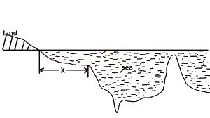
The Feature marked X in the above diagram is
Continental slope
a continental shelf
an ocean floor
an ocean ridge
a drowned island
Correct answer is B
No explanation has been provided for this answer.
Which of the following statement about the climatic data below is NOT true?
| J | F | M | A | M | J | J | A | S | O | N | D | |
| P(in mm) | 0 | 0 | 2 | 10 | 60 | 118 | 206 | 300 | 155 | 13 | 0 | 0 |
| T(in oC) | 21 | 23 | 27 | 30 | 31 | 29 | 26 | 25 | 25 | 27 | 25 | 25 |
Temperature range is 10oC
Maximum temperature is 31oC
There is rainfall for more than half the year
Total annual rainfall is 864mm
Average monthly rainfall is 70mm
Correct answer is E
No explanation has been provided for this answer.

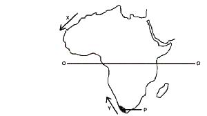
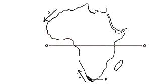
What type of climate experienced in the region 'P' shaded on the map
Cool temperate Western Margin
Tropical Marina
Tropical Monsoon
Mediterranean
Tropical continental
Correct answer is D
No explanation has been provided for this answer.

The ocean currents marked X and Y are the
Cold Saharan Current and cold Namibian current
Warm canaries Current an dwarm Bengueka current
Warm gulk-stream and warm Humbolt current
Cool Cnaries current and cool Benguela current
Warm canaries current and cool mozambique current
Correct answer is D
No explanation has been provided for this answer.

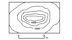
The above diagram on which the contour are in metres, shows a
drumlin
knoll
volcanic cone
Block mountain
mesa
Correct answer is B
No explanation has been provided for this answer.
JAMB Subjects
Aptitude Tests