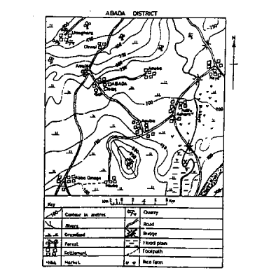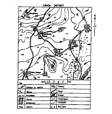
Stone crushing is an economic activity at
Noyo
Ameka
Ameka
Agub
Correct answer is C
Umughara, having the highest contour line is suspected to be mountainous and stone crushing is common around mountain.

The scale of the map in Representative Fraction(RF) is
1:25,000
1:100,000
1:200,000
1:50,000
Correct answer is B
From 0 to 2 on the map scale, using a ruler it is 1cm; and the distance on the ground 1km
scale: 1cm : 1km
N.B: 1km=1000m ≡ 100,000cm
Scale = 1cm : 100,000cm or 1 : 100,000
Industries are broadly classified into
primary, secondary and tertiary
mining, furniture making and cocoa processing
fishing, mining and food processing
primary, secondary and manufacturing
Correct answer is A
Industries are broadly classified into primary, secondary and tertiary. The primary sector involves the extraction of raw materials, the secondary sector involves the manufacturing of goods, and the tertiary sector involves the provision of services.
"An open forest with evergreen, thick leathery leaves and woody stems with deep roots" is known as
mediterranean vegetation
montane vegetation
hot desert vegetation
tropical rainforest
Correct answer is A
Mediterranean vegetation consists largely of broad-leaved evergreen shrubs having woody stems with thick roots.
A tremendous pressure or temperature change may lead to the formation of
gnesis
clay
limestone
granite
Correct answer is A
Gnesis is a metamorphic rock. Metamorphic rocks are formed from pre-existing rocks which have been changed as a result of great heat and pressure
JAMB Subjects
Aptitude Tests