Which of the following best interprets the scale "1cm represents 1km?
1:50 000
1:300 000
1:12 000
1/80 000
1:100 000
Correct answer is E
No explanation has been provided for this answer.

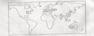
Which one of the areas shaded on the world map above is not an area of high population?
1
2
3
4
5
Correct answer is B
No explanation has been provided for this answer.
Explain the increasing importation of food to West Africa countries
Bad soils which cannot produce enough food
Progressive neglect of food production
Unfavourable climates for enough food production
Too large populations which cannot be satisfied locally
People's love for imported foods
Correct answer is B
No explanation has been provided for this answer.
Which of these statements is true of Africa?
Africa is the fourth largest continent in the world
Africa is the least urbanized continent
Tropical Africa is so warm that nowhere within it can find snow or ice
There are no more than ten land-locked countries in Africa
Africa produces nearly all the world's hard-wood timber.
Correct answer is B
No explanation has been provided for this answer.
Which one of the following states of Nigeria is a major cotton producer?
Kano
Borno
Bendel
Bauchi
Benue
Correct answer is D
No explanation has been provided for this answer.
JAMB Subjects
Aptitude Tests