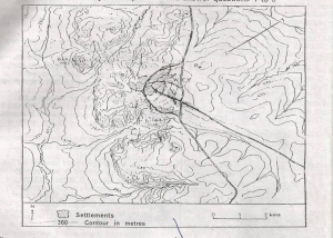
The central landform in the area shown on the map can be ...

The central landform in the area shown on the map can be described generally as a
Dissected broadsurfaced escarpment
Dissected massed inselberg lanscape
Broken block-fault mountain
Steep-sided tilted plateau
Correct answer is A
No explanation has been provided for this answer.
Similar Questions
The classification of clouds is based on a combination of form, height and? ...
A major percentage of the world's exports of citrus fruits is from the ...
The two major air masses affecting the climate of West Africa are the? ...
The sunshine duration of a place is recorded by a ...
ECOWAS is a viable economic region because of? ...
Which of the following factors accounts for large-scale fishing off the east coast of Canada? ...
Cities with populations over one million people in Africa include? ...
In the northern hemisphere, the summer solstice is experienced on? ...
One of the effects of rural-urban migration on the source region it? ...