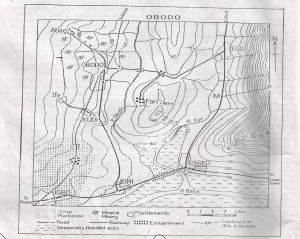
The drainage pattern of the area shown on the map is best...

The drainage pattern of the area shown on the map is best described as
Dendritic
Radial
Trellis
Rectangular
Annular
Correct answer is C
No explanation has been provided for this answer.
Similar Questions
All the following forms of subsistence farming in West Africa except ...
The average gradient of the road descending the spur into Bobo town is approximately ...
When it is 12.00 noon on longitude 30°W local time on longitude 75°E is? ...
The main cash crop produced in the area shaded on the map above is ...
Which of the following is not a process of wind erosion? ...
The sudd region has been highly valued for its? ...
Jebba,Lokoja and Onitsha are examples of ...
The length of the main road from Robo junction to Oseb junction is approximately ...